
Exploring the Adriatic Sea Dynamics using Advanced Data Assimilation Methods and Measurements (ADAM-ADRIA)

Exploring the Adriatic Sea Dynamics using Advanced Data Assimilation Methods and Measurements (ADAM-ADRIA)
Category
Projekti Hrvatske zaklade za znanost
Total cost
926.000
Start date
Aug 1st 2014
End date
Jul 31st 2018
Status
Done

Principal investigator

Principal Investigator: dr.sc. Ivica Janeković
Host institution for the project: Ruđer Bošković Institute, Zagreb
Project duration (months): 48
Project start: 1/8/2014

Using advanced numerical techniques and data assimilation (ROMS 4D-Var) at the same time with modern observations in a dynamically consistent way we aim to improve knowledge of the Adriatic Sea dynamics. During the project we will explore open questions in the field of physical oceanography of the Adriatic Sea, such as:

(I) dynamics of the dense water (DW), especially flow at the eastern side of the Adriatic Sea
(II) dynamics of the Po river outflow during stratified and vertically homogeneous conditions, as well as
(III) generation and dynamics of the sharp Istrian temperature and salinity front.

In order to capture those phenomena we plan to use advanced field observations (ADCPs, CTDs, towed computer-controlled CTD profiler, underway ship CTD), as well as high resolution nested numerical models.

This type of the measurements could arguably prove hypothesis on the importance of the East Adriatic DW contribution to the overall northern Adriatic DW budget. While measuring synchronously at the all important entrances of the Kvarner Bay, related to the DW dynamics, we can as well determine time-evolving dynamics of this socio-economically important region. ROMS 4D-Var system is a powerful tool capable to provide insight into a optimal observation setup, predictability and limits of the linearized adjoint techniques for a shelf sea as the Adriatic.

It is important to say that results from the project could serve as basis for many other research fields as ocean biology (DW bringing O2 at the bottom), chemistry or geology, or even applied like oil spills, integrated environmental planning, where correct dynamics are of a crucial importance. The project team members come from the four different institutions: Ruđer Bošković Institute, Faculty of Sciences, Meteorological and Hydrological Service, and Hydrographic Institute bringing unique competences for the proposed project to succeed. Last but not least, it is important to emphasize that after the project completion, all the insitu collected and model data will be made available to the scientific and applied research community.

Extended description

Data assimilation in physical oceanography, and especially advanced four-dimensional variational techniques (4D-Var), are still a novel approach in exploring the wide range of ocean dynamics scales that characterize the coastal shelf and marginal seas. The techniques are well established for the open ocean and at large temporal scales with vast sets of available observations (Moore et al., 2011; Powell et al., 2009; Broquet et al., 2009; Matthews et al., 2012). However, they are still an item of intense research when it comes to highly non-linear, coastal, boundary-nested, short-scales specific shelf areas (Janeković et al., 2013).

This is especially true where boundary conditions are part of the data assimilation control vector and can be altered via data assimilation itself. In these systems nested, child solution can be decoupled from its outer, parent, solution and special care must be taken to avoid complications (Janeković and Powell, 2012). During the minimization process one has the ability to adjust the model initial state, atmospheric forcing and boundary conditions in order to move the solution closer to observations, taking into account the time-evolving model and observation errors in a dynamically consistent way. The 4D-Var system provides powerful tool for resolving and analysing dynamics of the open ocean and coastal seas providing an insight and enabling explanation of many physical intricacies.

The Adriatic Sea, as the northernmost region of the Mediterranean Sea, is characterized with fast dynamical processes in physical, chemical, biological, and geological realm. Its shallow northern part (with depths up to 40 m), strong Po river inflow (mean annual flow ~ 1500 m3/s), one of the strongest tides in the whole Mediterranean Sea (Janeković et al., 2003; Janeković and Kuzmić, 2005), and spatially complex and strong Bora wind induced circulation (Kuzmić et al., 1988; Orlić et al., 1994; Kuzmić et al., 2006) makes it an ideal test bed for the activities proposed in this project. Fast changes and extreme events found in the region could also provide an early indication of climate changes, hence making dynamical representation of physical processes in the study area crucial in both short and long term.

Middle and southern Adriatic Sea regions, on the other hand, are important for many additional physical processes ranging from the dense water formation (one of the densest in the Mediterranean), and its path and accumulation (Vilibić et al., 2004; Vilibić et al., 2013; Mihanović et al., 2013), to processes related to the steep shelf inducing internal waves. In the Adriatic the steep shelf is descending toward its deepest region – the south Adriatic Pit (with depth up to 1200 m), having on its south-eastern border the Otranto Strait through which it communicates with the Ionian Sea.

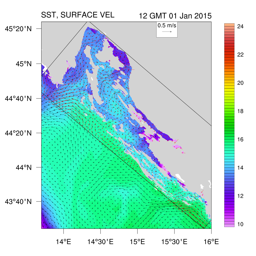
Current physical oceanographic knowledge of the Adriatic Sea is primarily based on either observations made at the sea surface via remote sensing techniques (e.g. satellite sea surface temperature), or in a water column via sporadic conductivity/temperature/depth (CTD) and/or Acoustic Doppler Current Profiler (ADCP) measurements or on theoretical work with or without numerical modelling support. The two approaches are usually applied separately. The only method that can combine the best of both worlds (the empirical and theoretical), in a dynamically consistent way, is the data assimilation. Advanced methods like 4D-Var can resolve and help understand many currently open issues, and gain new knowledge in research topics in global or local (e.g. Adriatic) frame.

Just to name a few:

  • What are the effects of the each individual type of the measurements (CTDs, ADCPs, SST) on the overall gain of new knowledge, what type of the measurements are more important and activate null space of the system? What new information is obtained from that specific data? What is the system sensitivity to the observations?
  • What is predictability and persistence time scale of the basin (i.e. Adriatic Sea)?
  • To what extent are processes nonlinear and what are the limits of the linearized adjoint data assimilation methods in such coastal region as Adriatic Sea?
  • What is the best estimate of dynamical state of the Adriatic Sea using both observations and numerical model in a dynamically consistent way?
  • What is dynamical contribution of the eastern Adriatic region to the overall dense water formation and budget?
  • What are the key processes in the region of Po fresh water inflow in the northern Adriatic during strongly stratified and homogeneous conditions?

Answers to those and many other questions are possible with the use of advanced numerical methods and the most advanced numerical ocean modelling systems, along with specific, carefully planned field observations.

In the proposed project we plan to use ROMS (Regional Ocean Modeling System, Shchepetkin and McWilliams, 2005) with 4D-Var data assimilation along with field observations, already existing or specifically made during the proposed project. Numerical ROMS model will be forced with realistic atmospheric momentum, heat and fresh water fluxes obtained from atmospheric numerical model. The project team has experience and uses operationally the ARW-WRF- Advanced Research Weather Forecasting System, as well as the outputs from the Aladin/ARPAGE model run operationally by the Croatian Meteorological and Hydrological Service. In addition, the fresh water rivers fluxes based on the observed river transports will be setup at a high resolution numerical model grid. Such calculations are CPU expensive; their execution is partly possible on our existing HPC cluster and fully feasible with the computational upgrade proposed in this project.

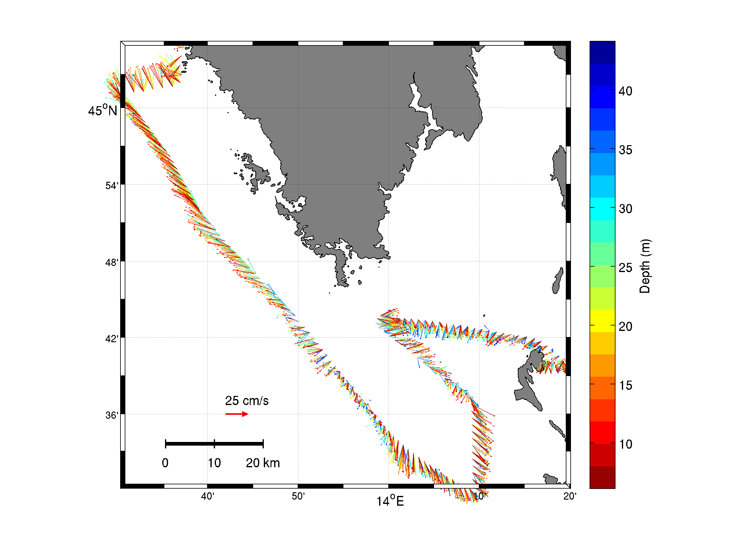
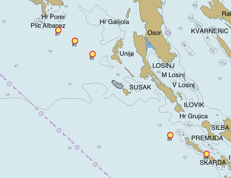
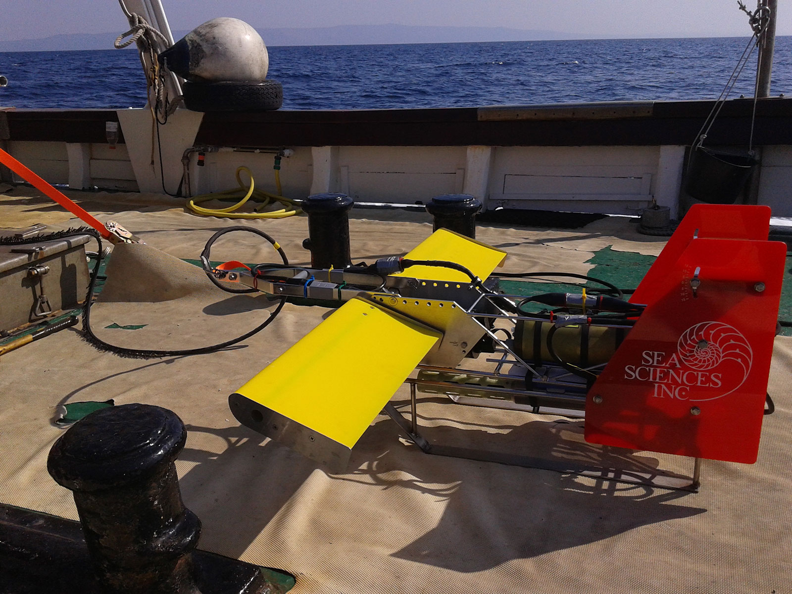
A use will also be made of the national Isabella cluster. Beside in numerical modelling, the project team has extensive experience in conducting field measurements with CTDs, ADCPs having at its disposal a spool of 10 ADCPs (Teledyne – RDI), 10 Sea Bird CTDs (4 x SBE16+, 1 x SBE49+, 5 x SBE26+), and a towed undulating computer-controlled CTD profiler. A locally operated receiving station provides acquisition and near real time data from NOAA polar orbiting satellites. Complementing the acquisition is a software system for advanced analysis and derivation of SST.

Expected project results, providing the answers to the posed fundamental questions, should also serve as the basis and source of information and data for many other scientific projects, requiring the knowledge of the Adriatic Sea dynamics and circulation. Multidisciplinary fields involving physical, biological (i.e. DW as a source of O2 at the bottom), chemical and/or geological aspects, as well as more application oriented works involving transport and fate of the oil spills, maritime safety and search and rescue missions, or even integrated environmental planning, could all benefit from our results. In the future, this project could be extended to evolve into a real-time operational model of the Adriatic Sea, helping to meet the requirements of the Croatian legislation as well as the EU marine frame directives.

Employing the expertise and advanced knowledge in both fields – field work and modelling, combined through a 4D-Var system, the assembled team can obtain improved picture of the relevant physical processes at high resolution, in both space and time. The project team members come from the four different institutions: Ruđer Bošković Institute, Faculty of Science, Croatian Meteorological and Hydrological Service, and Hydrographic Institute bringing unique competences for the proposed project to succeed.

Last but not least, it is important to emphasize that after the project completion, all the insitu collected and model data will be made available to the scientific and applied research community.

Results from the 1st year

  1. Improving the high performing cluster with fast infiniband interconnections using Mellanox FDR 56G cards and appropriate Mellanox infiniband switch. This step is crucial for for intensive numerical computations using ROMS model and data assimilation as exchange of data among the computing nodes is significant.
  2. Computing of the nonlinear model trajectory for the data assimilation in total of 5 years. Those fields are needed for error covariance matrix of the model. In total we have 776Gb of data served via openDAP thredds at http://home.irb.hr:40088/thredds/catalog/ROMS_DWF/catalog.html
  3. Setup of ship-born ADCP at research vessel Vila Velebita needed for simultaneous measurement of currents during the Istria Front CTD measurements.
  4. Based on numerical model analysis optimal deployment map is designed
  5. Long term deployment of the current and CTD stations at the entrance of Kvarner Bay.
  6. Istrian density front measurements using computer controlled vertical CTD profiler (undulator) along with ship-born ADCP measurements of currents.
  7. Gathering of remote sensed surface temperature fields needed for data assimilation
  8. ALADIN meteorological model simulations used for ROMS forcing fields (DHMZ)
  9. Recovery of ADCP and CTD data from the deployment
  10. Analysis of the ADCP data, preparation of the data for numerical model

Results from the 2nd year

  1. During the 2nd year of the project we collected available SST (Sea Surface Temperature) data for the whole Adriatic Sea and the period between 1.10.2014 till 1.10.2015. Data are based on the satellite remote sensing sensors from METOP-A, VIIRS and L3C.
  2. We have continued stream of Aladin meteo model needed for ocean model's forcing. Some improvements were made and we focused on the 1.10. 2014 - 1.10.2015. period when we have deployed instruments.
  3. Data analysis of the ship towed CTD profiler are completed for the Istrian front measurements. Results were presented at the NAdEx meeting at Trieste (prof. dr.sc. Zoran Pasarić, dr.sc. Mira Pasarić, mr.sc. Iva Međugorac).
  4. Data analysis of the recovered ADCP currents and bottom mounted SBE CTD temperature and salinity observations are finished. We have really nice, high quality, year long dataset of the current measurements at the major entrances of the Kvarner Bay. Results are presented at the Trieste NAdEx meeting (dr.sc. Mira Pasarić and dr.sc. Hrvoje Mihanović).
  5. We have made additional, better tuned simulations using ROMS model with the focus on the measurement period with inclusion of the another southern Adriatic nested subdomain. Model results were analysed and used for publications.

Literature

  1. Vilibić, I., Mihanović, H., Janeković, I., Šepić, J. 2016. Modelling the formation of dense water in the northern Adriatic: Sensitivity studies. Ocean modelling. 101, 17-29.
  2. Vilibić, I., Šepić, J., Mihanović, H., Kalinić, H., Cosoli, S., Janeković, I., Žagar, N., Jesenko, B., Tudor, M., Dadic., V., Ivanković, D. 2016. Self-Organizing Maps-based ocean currents forecasting system. Scientific Reports. 6.
  3. Ciglenečki, I., Janeković, I., Marguš, M., Bura-Nakić, E., Carić, M., Ljubešić, Z., Batistić, M., Hrustić, E., Dupčić, I., Garić, R. 2015. Impacts of extreme weather events on highly eutrophic marine ecosystem (Rogoznica Lake, Adriatic coast). Continental shelf research. 108, 144-155.
  4. Šepić, J., Međugorac, I., Janeković, I., Dunić, N., Vilibić, I. 2016. Multi-meteotsunami event in the Adriatic Sea generated by atmospheric disturbances of 25–26 June 2014, Pure and applied geophysics, in press.
  5. Tudor, M., Janeković, I. 2016. Modelling origin and transport fate of waste materials on the southeastern Adriatic coast (Croatia), Geofizika. 33, 31-44.
  6. Dutour Sikirić, M., Janeković, I., Tomažić, I., Kuzmić, M., Roland, A. 2015. Comparison of ALADIN and IFS model wind speeds over the Adriatic. Acta Adriatica. 56, 1, 67-82.
  7. Kuzmic, M., Grisogono, B., Li, X.M., Lehner, S., 2015. Examining deep and shallow Adriatic bora events, Q. J. R. Meteorol. Soc. DOI:10.1002/qj.2578.
  8. Mihanović, H., Vilibić, I., Janeković, I., Šepić, J., Tudor, M. 2015. modelling studies of dense water formation in the Adriatic Sea during the winter of 2012, 41st CIESM Congress, Kiel, Germany, 12-16 September 2016.
  9. Pasarić, M., Janeković, I., Mihanović, H., Orlić, M., Vilibić, I. 2016. High-frequency variability of the current field in the Northern Adriatic, 41st CIESM Congress, Kiel, Germany, 12-16 September 2016.
  10. Vilibić, I., Poulain, P. M., Orlić, M., Janeković, I., Dadić, V., Gerin, R., Kokkini, Z., Kovač, Z., Mauri, E., Mihanović, H., Pasarić, M., Pasarić, Z., Šepić, J., Tudor, M. the 2015 Northern Adriatic experiment: preliminary results, 41st CIESM Congress, Kiel, Germany, 12-16 September 2016.
  11. Šepić, J., Vilibić, I., Međugorac, I., Telišman-Prtenjak, M., Janeković, I., Dunić, N. 2015. Adriatic meteotsunami events of 25-26 June 2014: observations, numerical modelling and assessment of atmospheric processes, IUGG 26th General Assembly, Prague, Czech Republic, 22.06.-02.07.2015.
  12. Vilibić, I., Janeković, I., Mihanović, H., Šepić, J. 2015. Dense water formation sensitivity studies in the Northern Adriatic (Mediterranean Sea), IUGG 26th General Assembly, Prague,Czech Republic, 22.06.-02.07.2015.

Team members

  1. dr.sc. Ivica Janeković, IRB, leader of the project, numerical modelling , advanced 4D Var ROMS system, preparation and conducting field measurements and data analysis.
  2. dr.sc. Milivoj Kuzmić, IRB, remote sensing of SST
  3. dr.sc. Mathieu Dutour Sikirić, IRB, numerical modeling, ROMS model
  4. prof.dr.sc. Zoran Pasarić, PMF-GFZ, preparation and conducting CTD profiler measurements, data analysis
  5. dr.sc. Miroslava Pasarić, PMF-GFZ, preparation and conducting CTD profiler measurements, data analysis
  6. dr.sc. Hrvoje Mihanović, IOR, preparation and conducting CTD/ADCP measurements, data analysis
  7. mr.sc. Stjepan Ivatek-Šahdan, DHMZ, numerical modeling of the atmosphere, ALADIN model
  8. mr.sc. Iva Međugorac, PMF-GFZ, preparation and conducting CTD profiler measurements, data analysis
  9. dipl.ing. Damir Ptičar, PMF-GFZ, preparation and conducting CTD profiler measurements

This site uses cookies.. Some of these cookies are essential, while others help us improve your experience by providing insights into how the site is being used. For more detailed information on the cookies we use, please check our Privacy Policy.

Customise settings
  • Necessary cookies enable core functionality. The website cannot function properly without these cookies, and can only be disabled by changing your browser preferences.